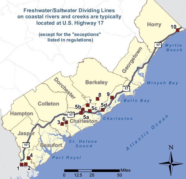
PRESS RELEASE. The dividing line between saltwater and freshwater on the rivers listed is defined in this section. All waters of the rivers and their tributaries, streams and estuaries lying seaward of the dividing lines are considered saltwaters, and all waters lying landward or upstream from all dividing lines are considered freshwaters for purposes of licensing and regulating commercial and recreational fishing. Except as otherwise provided below, the saltwater/freshwater dividing line is US Highway 17:
On Savannah River the dividing line is the abandoned Seaboard Railroad track bed located approximately one and three-fourths miles upstream from the US Highway 17A bridge.
Wright River is salt water for its entire length.
On Ashepoo River the dividing line is the old Seaboard Railroad track bed.
On New River the dividing line is at Cook’s Landing.
Wallace River (5a), Rantowles Creek (5b), Long Branch Creek (5c), and Shem Creek (5d) are saltwater for their entire lengths.
On Edisto River the dividing line is the abandoned Seaboard Railroad track bed near Matthews Canal Cut.
On Ashley River the dividing line is the confluence of Popper Dam Creek directly across from Magnolia Gardens.
On Cooper River the dividing line is the seaward shoreline of Old Back River at the confluence of Old Back River downstream from Bushy Park Reservoir.
Wando River is saltwater for its entire length.
On the Intracoastal Waterway in Horry County the dividing line is the bridge across the Intracoastal Waterway at the intersection of S.C. Highway 9 and US Highway 17. Measuring a Fish


